Hurricane Helene Gains Power as It Bears Down on Florida

[Stay on top of transportation news: Get TTNews in your inbox.]
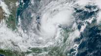
Hurricane Helene is strengthening as it sweeps past Mexico’s Yucatan Peninsula on its way to a collision Sept. 26 with Florida, where it has already triggered evacuations in advance of its powerful winds and dangerous storm surge.
Helene’s winds rose to 80 mph as it churned 85 miles north-northeast of Cozumel, Mexico, the U.S. National Hurricane Center said.
The storm has rapidly intensified, with its winds rising 35 mph in just one day as it enters the warm waters of the Gulf of Mexico. Helene is forecast to peak at 125 mph on Sept. 26 before landfall, making it a Category 3 on the five-step Saffir-Simpson scale, and there’s a chance it could be even stronger.
“Devastating hurricane-force winds are expected across portions of northern Florida and southern Georgia where the core of Helene moves inland,” Robbie Berg, a meteorologist at the hurricane center, wrote in his outlook. “Preparations to protect life and property should be completed early Thursday.”
9/24 11pm EDT: There is a danger of life-threatening storm surge from Tropical Storm #Helene along the entire west coast of the Florida Peninsula & Florida Big Bend, where a Storm Surge Warning is in effect. Residents in those areas should follow advice given by local officials. pic.twitter.com/Kbrt9dRV8S — NHC Storm Surge (@NHC_Surge) September 25, 2024
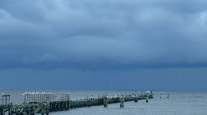
While Helene is forecast to make landfall in Florida’s rural Big Bend region, it will drop as much as 15 inches of rain across the state and the South as it moves inland, leading to widespread power outages and disrupting ground and air transportation. Rivers will rise, leading to days of flooding in some areas. The Big Bend is still recovering from Hurricane Debby, which struck that part of the state in early August.
Damages and economic losses will likely be in the $12 billion to $15 billion range, said Chuck Watson, a disaster modeler with Enki Research.
Helene is so large there is a chance dangerous storm surge could inundate all of western Florida, including Tampa Bay far to the south of where it’s forecast to come ashore, Berg wrote. Its forward speed also means its winds will still be strong as it punches its way inland.
Residents along the coast may be surprised because the storm surge is likely to be much higher than usual due to Helene’s size, said Ryan Truchelut, president of WeatherTiger. There could also be wind damage to crops in southwest and central Georgia.
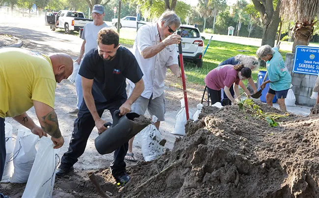
Residents fill sandbags at a public site in Tarpon Springs, Fla., on Sept. 24. (Douglas R. Clifford/Tampa Bay Times via AP)
Mandatory and voluntary evacuations have begun in 13 counties in Helene’s path, the Florida Division of Emergency Management said in an X post. In addition, Gov. Ron DeSantis declared an emergency in 61 counties. Sarasota County asked residents in several neighborhoods to start leaving their homes Sept. 25, according to the county’s website. Georgia Gov. Brian Kemp also declared an emergency across his state.
Helene will traverse an area of the Gulf with water temperatures ranging from 86 degrees to 89 degrees, meaning there is a lot of fuel to help it grow stronger. There is little storm-wrecking wind shear, so it’s possible Helene will reach Category 4 strength, said Tyler Roys, a meteorologist at commercial forecaster AccuWeather Inc.
🚨 9/25: 21 counties are under a hurricane warning for Tropical Storm #Helene, meaning, hurricane conditions are expected in these areas within 36hrs.
Finalize your disaster plans & continue to heed all orders from local officials! pic.twitter.com/nbarxsNLd3 — FL Division of Emergency Management (@FLSERT) September 25, 2024
Roys said Helene will most likely weaken before landfall, so he doesn’t expect it to come ashore in Florida on Sept. 26 as a Category 4 storm. But the area Helene will cover has seen several storms explode in strength in recent years, including Hurricane Michael in 2018, the last Category 5 hurricane to hit the U.S. mainland.
Ahead of Helene, heavy rain will bring flooding from Alabama to Virginia. Atlanta, the site of a critical late-season series between baseball’s New York Mets and the Atlanta Braves, will likely be awash.
As Helene moves inland over the weekend, its winds will rake the region, leading to many trees toppling and adding to power outage woes throughout Georgia, North Carolina and Tennessee, Roys said.
Want more news? Listen to today's daily briefing below or go here for more info: