Staff Reporter
Virginia Launches $3.8 Billion Hampton Roads Bridge-Tunnel Project

[Stay on top of transportation news: Get TTNews in your inbox.]
Virginia leaders recently gathered to break ground on expansion of the Hampton Roads Bridge-Tunnel, the largest infrastructure project in the state’s history.
Linking Hampton to Norfolk and Virginia Beach, the 3½-mile tunnel has two immersed tube tunnels connecting man-made islands, with trestle bridges leading to shore. It carries Interstate 64, an important east-west freight route that runs from Hampton Roads through Richmond and Charlottesville and into West Virginia.
The $3.8 billion project, which commenced Oct. 29, will involve increasing tunnel and interstate capacity along 9.9 miles of I-64 between Hampton and Norfolk.
More than 100,000 vehicles use the Hampton Roads Bridge-Tunnel every day during tourist season, according to the Virginia Department of Transportation. Trucks can traverse the facility, although height restrictions are in place for vehicles moving west.

In this episode, host Michael Freeze takes a look at the surprising ways trucking companies are building strong, resilient cultures and attracting talent that stays. Hear a snippet, above, and get the full program by going to RoadSigns.TTNews.com.
“For too long, traffic in the Hampton Roads region has bottlenecked at the tunnel,” Gov. Ralph Northam said. “Folks in this region deserve an easier, more reliable commute. This is the largest project in our history, and it will ensure that people can move around faster [and] that commerce flows more easily.”
Specifically, the project will add twin two-lane bored tunnels and widen the segments of I-64 leading up to the Hampton Roads Bridge-Tunnel on either shore. Construction crews will use a specialized tunnel boring machine that is being built in Germany. The machine is expected to arrive in Hampton Roads in 2021, at which point it will be assembled, a process that’s expected to take several months. Tunneling operations are scheduled to begin in early 2022. The project is slated for completion in November 2025.
Kevin Page, executive director of the Hampton Roads Transportation Accountability Commission, described the region as a confluence of cities in a “very tight-knit location” that experiences traffic congestion that has remained snarled even during the coronavirus pandemic.
Seen under construction in 1955, the Hampton Roads Bridge-Tunnel between @NorfolkVa & @cityofHampton opened in 1957 & was expanded in 1976. The current #HRBT Expansion, the largest infrastructure project in #Virginia history, is underway & expected to be completed in late 2025. pic.twitter.com/GRcXo0WYQ8 — VDOT (@VaDOT) October 30, 2020
“Like any other major metropolitan region with high population centers, we do suffer from the commonplace backup and congestion,” Page told Transport Topics. “One thing that COVID has done for us is proven that the congestion at the Hampton Roads Bridge-Tunnel has sustained even through COVID. [It] further emphasizes the need to do this project.”
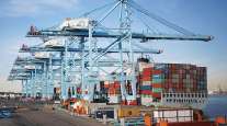
Contributing to the region’s congestion are the Naval Station Norfolk and the Port of Virginia, both of which generate traffic. As the largest naval complex in the world, Naval Station Norfolk supports the U.S. Atlantic Fleet’s operations. Norfolk International Terminals, located at the Port of Virginia, processes thousands of truck moves every day.
Another challenge of Hampton Roads is its geography, which is characterized by many bodies of water, such as the York and James rivers, which flow into the Chesapeake Bay. The area is served by one interstate — I-64 — and its derivatives. Residents depend on the interstate because water crossings to traverse the region’s many rivers are limited.
“In Hampton Roads, in order for us to ‘go across town’ to either do business or visit family, we have to take the interstate highway to do that,” Page said. “We have these massive water crossings. Our interstate highway system is our local road system to many people. You can’t avoid it.”
Looking toward future regional projects, Page said the Bowers Hill interchange will be studied for major infrastructure improvements. Located 14 miles southwest of the Port of Virginia, the Bowers Hill interchange represents the confluence of interstates 664, 64 and 264, U.S. routes 460, 58 and 13 and state Route 191. Page said many truckers leaving the port rely on this interchange.
“As truckers are coming out of the Virginia International Gateway, trying to get down 664 to Bowers Hill, they hit a lot of congestion during peak periods of the day, and we’re about to take care of that, too.”
Want more news? Listen to today's daily briefing:
Subscribe: Apple Podcasts | Spotify | Amazon Alexa | Google Assistant | More


