Associated Press
Evacuations Urged as Hurricane Henri Heads North

[Stay on top of transportation news: Get TTNews in your inbox.]
Preparations for a storm grew more urgent Aug. 21 as the newly upgraded Hurricane Henri closed in on the Northeast.
The storm’s latest track put it course to collide Aug. 22 with a long stretch of coastline, with hurricane warnings extending from near the old whaling port of New Bedford, Mass., across the luxurious oceanfront estates of New York’s Hamptons, to the summer getaway of Fire Island.
Intense winds and potentially dangerous tidal surges were expected as far east as Cape Cod and as far west as the New Jersey shore, and utilities warned ensuing power outages could last a week or even more.

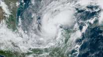
An OES-16 East GeoColor satellite image of Hurricane Henri provided by NOAA via Associated Press.
Henri was veering a bit further west than originally expected, and if that track holds, it would have eastern Long Island in its bull’s-eye rather than New England, which hasn’t taken a direct hit from a hurricane since the deadly Hurricane Bob in 1991.
New York hasn’t had a direct hit from a powerful cyclone since Superstorm Sandy wreaked havoc in 2012. Some of the most important repairs from that storm have been completed, but many projects designed to protect against future storms remain unfinished.
Residents and visitors on Fire Island, a narrow strip of sandy villages barely above sea level off Long Island’s southern coast, were urged to evacuate. The last boats out were to leave at 10:40 p.m. EDT Aug. 21; after that, officials said, there may be no way out for people who decide to ride out the storm.
“If they do not leave the island today, they will be stuck on the island and we do not know what kind of conditions they may be facing. But they could be difficult. They could be dangerous,” said Suffolk County Executive Steve Bellone.
Here #Henri comes -- as seen on satellite. It's about 24 hours away from the Northeast, but outer effects will be felt earlier. pic.twitter.com/AryAuvmfhV — NWS Northeast RFC (@NWSNERFC) August 21, 2021
Gov. Andrew Cuomo pleaded with New York residents to make last-minute preparations, warning that heavy rain, winds and storm surges from Henri could be as devastating as Superstorm Sandy in some parts of the state.
“We have short notice. We’re talking about tomorrow,” Cuomo said. “So if you have to move, if you have to stock up, if you have to get to higher ground, it has to be today. Please.”
Service on some eastern branches of the Long Island Rail Road, a major commuter rail system, will be suspended at midnight, said Cuomo.
The governor, who will leave office in two days following a sexual harassment scandal, warned that heavy rains were expected to create problems far up into the Hudson River Valley.
With a top wind speed of 75 mph Aug. 21, Henri sped up to move north-northeast at 17 mph as of the afternoon. It’s still about 395 miles south of Montauk Point on New York’s Long Island.
Southampton Town Supervisor Jay Schneiderman said the town was considering issuing a voluntary evacuation advisory for about 6,000 people. He said current storm models show that the storm’s center would run “smack on the town of Southampton.” He described a run on supplies like batteries and flashlights as people “are starting to wake up.”
“Right now it seems like a sunny summer day, but, you know, by this time tomorrow we’re going to be in the middle of potentially a severe hurricane,” he said.
Regardless of its exact landfall, broad impacts were expected across a large swath of the Northeast, extending inland to Hartford, Conn.; and Albany, N.Y.; and eastward to Cape Cod, which is teeming with tens of thousands of summer tourists.
Storm surge between 3 and 5 feet is possible from Flushing, N.Y., to Chatham, Mass., and for parts of the North Shore and South Shore of Long Island, the hurricane center said.
Rainfall between 3 to 6 inches is expected Aug. 22-23.

Rob Edwards, from Newport, R.I., adds extra lines to secure his boat at the Goat Island Marina. (Stew Milne/Associated Press)
The weather service warned of the potential for damaging winds and widespread coastal flooding, and officials in Massachusetts, Connecticut and New York cautioned that people could lose power for days. Authorities advised people to secure their boats, fuel up their vehicles and stock up on canned goods.
Gov. Ned Lamont warned Connecticut residents they should prepare to “shelter in place” from the afternoon of Aug. 22 through at least the morning of Aug. 23 as the state braces for the first possible direct hit from a hurricane in decades.
In the Hamptons, the celebrity playground on Long Island’s east end, officials warned of dangerous rip currents and flooding that’s likely to turn streets like the mansion-lined Dune Road into lagoons.
“We have a lot of wealthy people. There’s no doubt that we do, but everybody pulls together in an emergency,” Schneiderman said. “So, you know, yeah, there are people hanging out on their yachts at the moment drinking martinis, but they’re also starting to talk about this storm and I’m sure they’re going to want to be helpful.”
Want more news? Listen to today's daily briefing below or go here for more info:


