Helene Races Toward Florida as Major Category 3 Storm

[Stay on top of transportation news: Get TTNews in your inbox.]
CRAWFORDVILLE, Fla. — Hurricane Helene could cause a “nightmare” scenario of catastrophic storm surge in northwestern Florida, officials warned Sept. 26 as they urged residents to heed evacuation orders ahead of the enormous storm, which is expected to cause significant damage hundreds of miles inland across much of the southeastern U.S.
Helene was upgraded to a major Category 3 storm the afternoon of Sept. 26 ahead of its expected evening landfall on Florida's northwestern coast. Hurricane and flash flood warnings extend far beyond the coast up into south-central Georgia.
It was already starting to be felt in the afternoon, with tropical storm force winds hitting the state and water lapping over a road on the northern tip of Siesta Key near Sarasota. And rain has started battering places like Asheville, North Carolina, where a 7-inch deluge has raised flooding concerns.
With forecasters also warning of tornadoes, damaging winds and mudslides, the governors of Florida, Georgia, the Carolinas and Virginia have all declared emergencies, as did President Joe Biden for several of the states. He is sending the head of the Federal Emergency Management Agency to Florida on Sept. 27 to view the damage.
Florida Gov. Ron DeSantis said the morning of Sept. 26 that models suggest Helene will make landfall further east, lessening the chances for a direct hit on the capital city of Tallahassee, whose metro area has a population of around 395,000.
The shift has the storm aimed squarely at the sparsely-populated Big Bend area, home to fishing villages and vacation hideaways where Florida’s Panhandle and peninsula meet. Shuttered gas stations dotted the two-lane highway, their windows boarded up with plywood.
Very large Hurricane #Helene strengthening and expected to make landfall as a major hurricane in the Florida Big Bend region this evening. A catastrophic and deadly storm surge is likely. Preparations should be rushed to completion. Here are the latest Key Messages.… pic.twitter.com/ht7XaEygSg — National Hurricane Center (@NHC_Atlantic) September 26, 2024
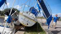
Philip Tooke, a commercial fisherman who took over the business his father founded near the region's Apalachee Bay, plans to ride out this storm like he did during Hurricane Michael and the others – on his boat. “This is what pays my bills,” Tooke said of his boats. “If I lose that, I don’t have anything.”
Many, though, were heeding the mandatory evacuation orders that stretched from the Panhandle south along the Gulf Coast in low-lying areas around Tallahassee, Gainesville, Cedar Key, Lake City, Tampa and Sarasota.
Among them was Sharonda Davis, one of several gathered at a Tallahassee shelter worried their mobile homes wouldn’t withstand the winds. She said the hurricane's size is “scarier than anything because it’s the aftermath that we’re going to have to face.”
Federal authorities were staging search-and-rescue teams as the National Weather Service office in Tallahassee forecast storm surges of up to 20 feet (6 meters) and warned they could be particularly “catastrophic and unsurvivable” in Apalachee Bay. It added that high winds and heavy rains also posed risks.
“Please, please, please take any evacuation orders seriously!” the office said, describing the surge scenario as “a nightmare.”
This stretch of Florida known as the Forgotten Coast has been largely spared by the widespread condo development and commercialization that dominates so many of Florida’s beach communities. The sparsely populated region is loved for its natural wonders — the vast stretches of salt marshes, tidal pools and barrier islands; the dwarf cypress trees of Tate’s Hell State Forest; and Wakulla Springs, considered one of the world’s largest and deepest freshwater springs.
Anthony Godwin, 20, found one gas station outside Crawfordville where the tanks were still running to fill up before heading west toward his sister’s house in Pensacola.
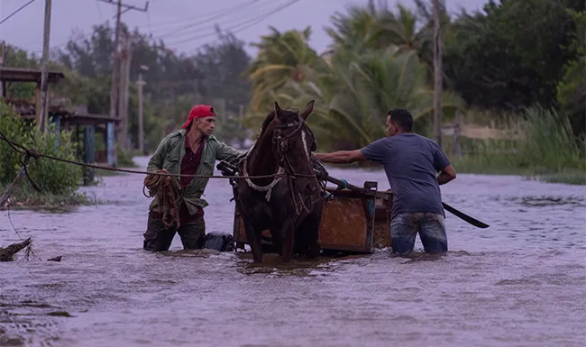
People traverse a flooded street with a horse-drawn carriage after the passage of Hurricane Helene in Guanimar, Artemisa province, Cuba, on Sept. 25. (Ramon Espinosa/AP)
“It’s a part of life. You live down here, you run the risk of losing everything to a bad storm,” said Godwin, who lives about a half-mile from the water in the coastal town of Panacea. During Hurricane Michael in 2018, Godwin said the water came up to the end of the driveway of his family’s home when the storm surge reached about 12 feet.
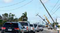
Along Florida’s Gulf Coast, school districts and multiple universities have canceled classes. Airports in Tampa, Tallahassee and Clearwater were closed Sept. 26, while cancellations were widespread elsewhere in the state and beyond.
Helene was about 195 miles southwest of Tampa on the afternoon of Sept. 26 and moving north-northeast at 16 mph with top sustained winds of 111mph.
While Helene will likely weaken as it moves inland, its “fast forward speed will allow strong, damaging winds, especially in gusts, to penetrate well inland across the southeastern United States,” including in the southern Appalachian Mountains, the hurricane center said. The center posted lesser tropical storm warnings as far north as North Carolina, and warned that much of the region could experience prolonged power outages, toppled trees and dangerous flooding.
Florida is preparing for widespread impacts from Hurricane Helene. Sixty-one of Florida’s 67 counties are currently under a state of emergency.
Do not get wedded to the “cone,” as hazards such as tornados, flooding, and storm surge can create dangerous conditions far beyond… pic.twitter.com/q568YSg2Nu — Ron DeSantis (@GovRonDeSantis) September 25, 2024
Helene had swamped parts of Mexico’s Yucatan Peninsula on Sept. 25, flooding streets and toppling trees as it passed offshore and brushed the resort city of Cancun.
The storm formed Sept. 24 in the Caribbean Sea. In western Cuba, Helene knocked out power to more than 200,000 homes and businesses as it brushed past the island.
Helene is forecast to be one of the largest storms in breadth in years to hit the region, said Colorado State University hurricane researcher Phil Klotzbach. He said since 1988, only three Gulf hurricanes were bigger than Helene’s predicted size: 2017’s Irma, 2005’s Wilma and 1995’s Opal.
Areas 100 miles north of the Georgia-Florida line can expect hurricane conditions. More than half of Georgia’s public school districts and several universities canceled classes.
For Atlanta, Helene could be the worst strike on a major Southern inland city in 35 years, said University of Georgia meteorology professor Marshall Shepherd.
*** For the latest on #Helene, visit https://t.co/6lVNq0o2Jk, & see our one-stop page, https://t.co/yT6344byUu:
-- Latest forecast info & maps from @NHC_Atlantic.
--@NOAASatellites imagery.
-- Tides & currents data from @noaaocean.
-- Hurricane prep tips.
--& more. pic.twitter.com/MME3Ma2p3c — NOAA (@NOAA) September 24, 2024
More than 200 miles to the south, near Valdosta, Ga., residents filled up sandbags at a fire station as rain drizzled. Just outside town, Joe Overby boarded up a storage building as he prepared to ride out the hurricane, worrying about oaks in his yard that were damaged last year by Idalia. “I’m afraid this time they’re going to come down,” Overby said.
Landslides were possible in southern Appalachia, and rainfall was expected as far away as Tennessee, Kentucky and Indiana.
President Joe Biden approved an emergency declaration Sept. 26 for Georgia after issuing one for Florida earlier in the week. Federal authorities have positioned generators, food and water, along with search-and-rescue and power restoration teams.
Helene is the eighth named storm of the Atlantic hurricane season, which began June 1. The National Oceanic and Atmospheric Administration has predicted an above-average Atlantic hurricane season this year because of record-warm ocean temperatures.
In further storm activity, Tropical Storm Isaac formed Sept. 25 in the Atlantic and was expected to strengthen as it moves eastward across the open ocean, possibly becoming a hurricane by the end of the week, forecasters said. Isaac was about 820 miles east-northeast of Bermuda with top sustained winds of 50 mph, according to the hurricane center, which said its swells and winds could affect parts of Bermuda and eventually the Azores by the weekend.
In the Pacific, former Hurricane John reformed Sept. 25 as a tropical storm and strengthened Sept. 26 back into a hurricane as it threatened areas of Mexico’s western coast with flash flooding and mudslides. Officials posted hurricane warnings for southwestern Mexico.
Want more news? Listen to today's daily briefing above or go here for more info
John hit the country’s southern Pacific coast late Sept. 23, killing at least two people, triggering mudslides, and damaging homes and trees. It grew into a Category 3 hurricane in a matter of hours and made landfall east of Acapulco. It re-emerged over the ocean after weakening inland.
Hollingsworth reported from Kansas City, Mo. Associated Press journalists Seth Borenstein in New York; Jeff Amy in Atlanta; Danica Coto in San Juan, Puerto Rico; Andrea Rodríguez in Havana; Mark Stevenson and María Verza in Mexico City; and Claire Rush in Portland, Ore., contributed to this report.